We’re creating three-dimensional models of the central business district (CBD) that will be available for public use.
How the 3D models were created
Our 3D models were built by Sydney-based company AAM. Their GeoCirrus software uses LIDAR (light sensing and ranging) technology, which calculates the exact distance to an object by bouncing laser light off it. The resulting 3D building outlines are combined with high-resolution aerial photographs, existing geographical information system (GIS), and other data to create a detailed and accurate city model.
AAM completed a flyover of the central city in January 2018 to record LIDAR data for the current model.
How we will use the models
The 3D model will be used for consultation purposes, augmented reality projects, visualisations such as the pre- and post-quake CBD visualisation, and by the members of the public to explore a digital version of their city.
Expected outcomes
- Urban planners can model alternative scenarios or proposed master plans in a highly visual and accessible way.
- Advanced views and tools, such as shadow analysis, will help planners to assess resource consents.
- The usual plans and indicative images provided in public consultations can be augmented with three‑dimensional models that help residents, councillors, and community groups to visualise new projects more clearly.
- Using an intuitive, interactive view for consultations will encourage engagement, and inspire more residents to have their say.
- Model data can be used in future augmented reality and virtual reality applications.
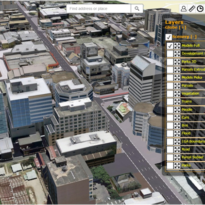
3D model viewer
Go to the Christchurch CBD 3D model viewer.
2018 3D model files available to download here: